
AB 2513 modernizes California’s wildfire policy by recognizing Southern California’s chaparral and shrubland ecosystems, accelerating resilience projects statewide ✏️📄 #WildfireResilience #CaliforniaPolicy
Discover Decades of Bird Data with IRC’s New Public Dashboard

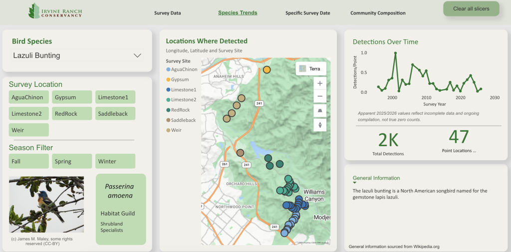
If you have ever wondered what is happening with bird populations in Orange County’s backyard, decades of data are now available for the public to explore. Irvine Ranch Conservancy (IRC) has launched a new interactive data tool, the Bird Point Count Dashboard, which showcases long‑term bird monitoring data collected across the land over many years.
The dashboard not only highlights which species were observed but also provides insight into bird detections over time and shifts in their community structure. With multiple pages to navigate, users can explore Orange County’s rich diversity of birds, track when migratory species pass through and learn how bird detections have changed over the years. Filters on the dashboard allow users to explore data by specific locations or time periods, making it easy to focus on areas or timeframes of interest.
All of the data comes from standardized point counts conducted over the past three decades; many of them collected by Sea and Sage Audubon volunteers even before IRC was established. During a point count, staff and trained volunteers record every bird they see and hear from a fixed location over a five-minute period. These counts are repeated at the same spots roughly six times a year, typically in the morning. The dashboard even includes the exact point count locations and their corresponding results. Point count locations are found in areas that can be accessed through guided activities and Wilderness Access Days. For more information on these activities, visit letsgooutside.org.
Making this dashboard public offers the community an inside look at what is happening on the land. Users can see long‑term trends, including how species respond to major events. For example, following the 2007 and 2020 fires, the data indicate declines in some species and increases in others, illustrating how bird communities responded differently to post-fire habitat changes. Wrentit detections dropped after fire, likely due to a reduction of dense shrubs, while Lazuli Buntings often increase shortly afterward, showing a preference for more open conditions. Now, anyone curious about IRC’s research can explore the same information firsthand.
This tool is designed for a wide range of users, from seasoned birders to those newly curious about Orange County’s wildlife, from community members interested in habitat restoration to scientific audiences seeking reliable long‑term data. By opening access to decades of bird counts, IRC hopes to inspire new research, strengthen transparency and deepen public understanding of the land.
The more people learn about local species and how they respond to changing conditions, the more connected they become to the landscapes around them. That connection often leads to greater participation in stewardship and conservation efforts. Start exploring!
Related Posts


